 Metadata Vlaanderen
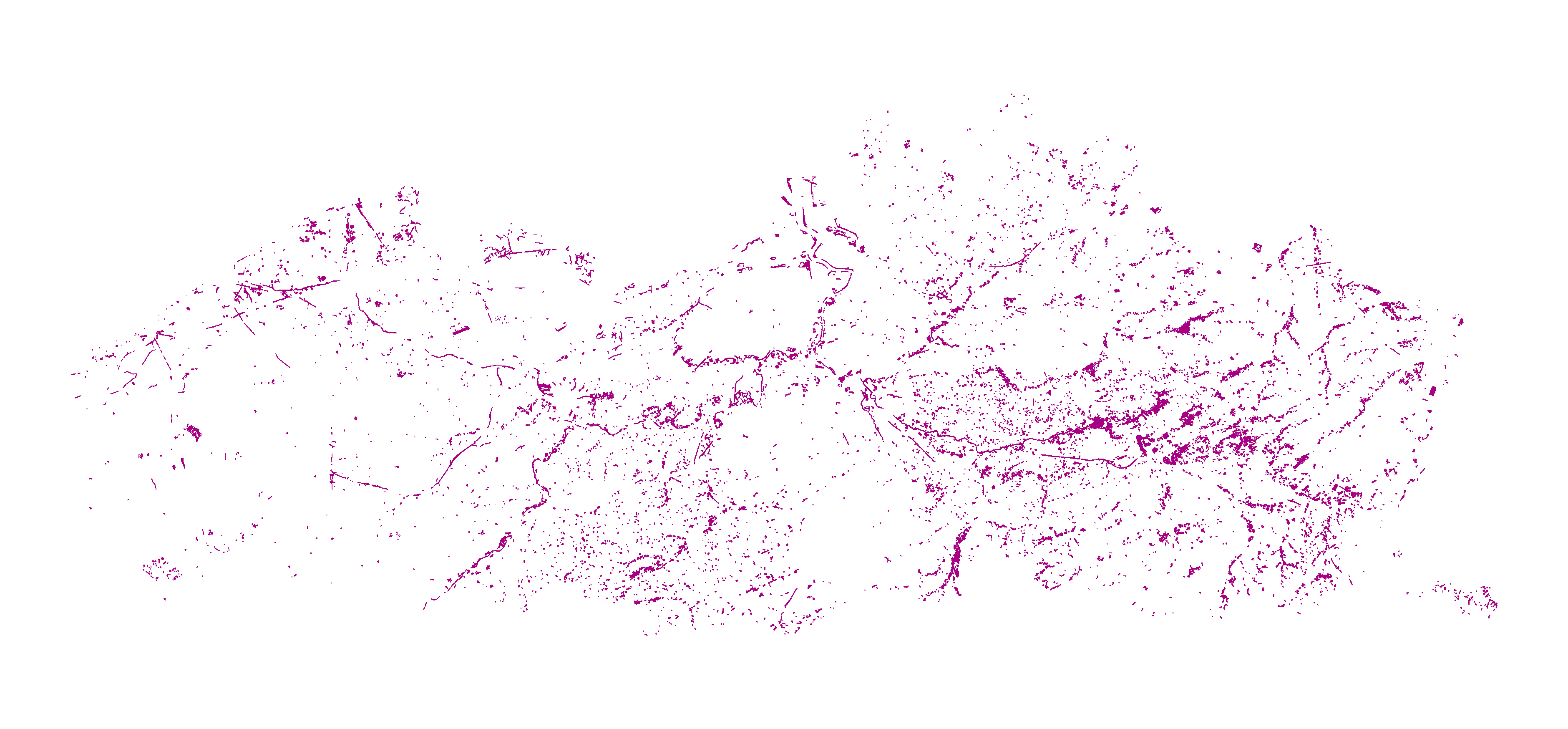
Vegetaties van regionaal belang - Toestand 2020, Vlaanderen
Bij de opmaak van een natuurbeheerplan, een projectsubsidie natuur, of andere gelijkgestelde instrumenten ter realisatie van de IHD (instandhoudingsdoelstellingen), kunnen welbepaalde natuurstreefbeelden tot doel gesteld worden voor vegetaties, leefgebieden van soorten of procesgestuurde natuur. Het Instandhoudingsbesluit (BVR 20/06/2014, art. 8) stelt echter dat het realiseren van de Europees te beschermen boshabitattypen niet mag leiden tot een betekenisvolle verslechtering of achteruitgang van de zgn. vegetaties van regionaal belang (VRB’s), zoals gespecificeerd in bijlage bij het besluit. De VRB’s zijn gedefinieerd aan de hand van welbepaalde karteringseenheden uit de Biologische Waarderingskaart (BWK) en Natura 2000 Habitatkaart. Door deze selectie te vertalen naar een ruimtelijk bestand is het voor elke opsteller van een natuurbeheerplan duidelijk op welke percelen of delen van percelen art. 8 van het Instandhoudingsbesluit van toepassing is.Deze kaartlaag geeft de best beschikbare informatie anno 2020 weer over de verspreiding van de vegetaties van regionaal belang. Dit kan een vereenvoudiging zijn van de werkelijkheid op terrein. Te allen tijde geldt de reële situatie op het terrein voor toepassing t.b.v. het beleidsmatig en wettelijk kader.Noch de auteurs noch het Instituut voor Natuur- en Bosonderzoek kunnen verantwoordelijk gesteld worden voor gebeurlijke fouten en de gevolgen die daaruit kunnen voortvloeien.
Simple
- Alternate title
-
VRB
- Date (Creation date)
- 2020-12-01
- Edition
-
Toestand 2020
- Citation identifier
- ef907dd4-29d7-48a2-a85b-fb0153950d15
- Purpose
-
Om een eenduidig instrument ter beschikking te stellen als hulpmiddel bij de opmaak van een natuurbeheerplan of projectsubsidie natuur, geeft dit bestand een ruimtelijk expliciete weergave van de zgn. vegetaties van regionaal belang. Die zones mogen conform het Instandhoudingsbesluit (BVR 20/06/2014) niet betekenisvol achteruitgaan bij realisatie van doelen voor de Europees te beschermen boshabitattypen. Het bestand laat toe dat iedere opsteller van een natuurbeheerplan eenzelfde invulling geeft aan de definitie van vegetaties van regionaal belang zoals voorzien in de bijlage bij het Instandhoudingsbesluit.
- Status
- Historical archive
https://www.vlaanderen.be/inbo/home/
https://www.vlaanderen.be/inbo/home/
https://www.vlaanderen.be/inbo/home/
- Keywords
-
-
biologische waardering
-
- Theme
-
-
biologische waarderingskaart
-
bwk
-
biotoopinformatie
-
biotoopzeldzaamheid
-
diversiteit
-
ecotoop
-
faunistisch belangrijk gebied
-
habitattype
-
landschapselelement
-
natuurbeleid
-
natuurbehoud
-
natuurstreefbeeld
-
flora
-
Natura 2000
-
regionaal belangrijk biotoop
-
rbb
-
instandhoudingsdoelstellingen
-
IHD
-
vegetatie van regionaal belang
-
VRB
-
- Specific usage
-
Zones waar art. 8 van het Instandhoudingsbesluit van toepassing is (BVR 20/06/2014, art. 8)
https://www.vlaanderen.be/inbo/home/
- Use limitation
-
Geen beperkingen op de publieke toegang.
- Use limitation
-
Toegangs- en (her)gebruiksvoorwaarden
- Access constraints
- Other restrictions
- Use constraints
- Other restrictions
- Other constraints
- Geen beperkingen op de publieke toegang.
- Other constraints
- Modellicentie voor gratis hergebruik
- Title
-
Biologische Waarderingskaart en Natura 2000 Habitatkaart - Toestand 2020
- Alternate title
-
BWK22
- Alternate title
-
Habitatkaart
- Date (Publication date)
- 2020-12-11
- Edition
-
Toestand 2020
- Citation identifier
- e3d76184-3e32-4dee-bf70-44cab9780733
- Aggregate Datasetindentifier
- e17fe655-987c-4c5f-bbae-b10dcd4fccc3
- Association Type
- Source
- Title
-
Groenkaart Vlaanderen 2015
- Date (Publication date)
- 2017-12-06
- Citation identifier
- 57c40aa5-e94d-447c-a5c6-4afcdd7b0a9a
- Aggregate Datasetindentifier
- e302a6a1-65b3-433e-8828-b26dfd5893d9
- Association Type
- Source
- Spatial representation type
- Vector
- Denominator
- 3000
- Distance
- 0 m
- Language
- Nederlands; Vlaams
- Character set
- UTF8
- Topic category
-
- Environment
- Description
-
Vlaams Gewest
))
- Begin date
- 2020-11-11
- End date
- 2022-10-31
- Supplemental Information
-
Het ruimtelijk bestand met de vegetaties van regionaal belang is tot stand gekomen door een selectie te nemen van de betreffende karteringseenheden van de Biologische Waarderingskaart dan wel de Natura 2000 Habitatkaart (Toestand 2020; De Saeger et al. 2020), zoals expliciet vermeld in de bijlage bij het Instandhoudingsbesluit (BVR 20/06/2014). De selectie gebeurde op basis van de eerste twee eenheden (EENH1, EENH2, HAB1, HAB2). Voor elke polygoon uit deze selectie werd het oppervlakte-aandeel bepaald met vegetatie hoger dan 3 meter. Hiervoor werd de categorie “Hoog groen” gebruikt uit de segmentatie van de hoge resolutie luchtfoto’s uit 2015, zoals bepaald volgens dezelfde methodologie als de publiek beschikbare Groenkaart Vlaanderen 2015. Polygonen met een oppervlakte-aandeel “Hoog groen” groter dan 90% werden uit de selectie weggelaten. Voor de overige polygonen wordt aangenomen dat op althans het actueel niet verboste deel ervan art. 8 van het Instandhoudingsbesluit van toepassing is. Het deel dat effectief gevrijwaard moet worden staat in relatie tot het aandeel van de VRB(‘s) (veld PHAB), de zekerheid van aanwezigheid ervan (veld HABLEGENDE), en het actueel reeds verboste aandeel zoals indicatief aangegeven door het aandeel van de categorie “Hoog groen”. Dat oppervlakte-aandeel “Hoog groen” zit vervat in het attribuut HOOGGROEN. Voor de juiste ligging van de oppervlakte “Hoog groen” dan wel het effectief te vrijwaren deel met VRB(‘s) binnen een polygoon is een interpretatie van recente luchtfoto’s nodig, al dan niet in combinatie met een evaluatie op het terrein.
- Unique resource identifier
- Belge 1972 / Belgian Lambert 72
- Distribution format
-
Name Version Esri Shape nvt
GML 2.1.2
Esri File Geodatabase 10.4.1
GeoPackage nvt
Distributor
https://www.vlaanderen.be/inbo/home/
- Fees
-
gratis
- Ordering instructions
-
Download
Digital transfer options
- Units of distribution
-
Vlaams Gewest
- Transfer size
- 0
- OnLine resource
-
Vegetaties van regionaal belang
(
WWW:DOWNLOAD-1.0-http--download
)
Download bestanden (shp + GML + FGDB + Geopackage)
- Hierarchy level
- Dataset
- Statement
-
Aanmaak Vegetaties van Regionaal Belang
- Description
-
Kartering van de Biologische Waarderingskaart - Natura 2000 Habitatkaart, Toestand 2020: Schermdigitalisatie van de op terrein afgebakende percelen en gebieden (inclusief inhoudelijke controle en aanpassingen) met de op dat ogenblik beschikbare digitale orthofoto's van het NGI als achtergrond (Ondersteunend Centrum GIS-Vlaanderen). Gemiddeld wordt ingezoomd tot 1/3000. Aanvullingen, bvb. grenzen die niet uit de digitale orthofoto’s kunnen afgeleid worden, gebeuren aan de hand interpretatie van de analoge Topografische kaarten van het NGI.
- Description
-
Kartering van de Biologische Waarderingskaart - Natura 2000 Habitatkaart, Toestand 2020: Controle van de schermdigitalisatie met de meest recente digitale orhofoto's van het NGI als achtergrond (Ondersteunend Centrum GIS-Vlaanderen). Elke nieuwe reeks ortho’s laat een betere interpretatie toe, zowel op inhoudelijk als geografisch vlak. Hoe recenter de digitalisatie, hoe beter de kwaliteit van de orthofoto’s en bijgevolg hoe beter de digitalisatie. Aanvullingen, bvb. grenzen die niet uit de digitale orthofoto's kunnen afgeleid worden, gebeuren aan de hand van de digitale topografische kaarten. Gemiddeld wordt ingezoomd tot 1/3000.
- Description
-
Kartering van de Biologische Waarderingskaart - Natura 2000 Habitatkaart, Toestand 2020: Topologie opbouwen van de individuele bestanden in een geodatabase (clustertolerance 0,1 m). Onderwerpen aan controleprogramma om uniforme, foutloze bestanden te bekomen.
- Description
-
Selectie van de karteringseenheden uit de Biologische Waarderingskaart en Natura 2000 Habitatkaart, Toestand 2020 zoals vermeld in bijlage bij het instandhoudingsbesluit (BVR 20/06/2014), uit de velden EENH1, EENH2, HAB1 of HAB2.
- Description
-
Verwijdering van de polygonen met een oppervlakte-aandeel groter dan 90% van de categorie “hoog groen” zoals afgeleid uit de segmentatie van de hoge resolutie luchtfoto’s uit 2015, en bepaald volgens dezelfde methodiek als de Groenkaart Vlaanderen 2015 (publiek beschikbaar; zie verwante dataset)
- Included with dataset
- Yes
- Feature catalogue citation
Meta-metadata
- File identifier
- 9bee6977-b70a-46e9-a4e2-69f7c375af0b XML
- Metadata language
- Nederlands; Vlaams
- Character set
- UTF8
- Hierarchy level
- Dataset
- Hierarchy level name
-
Dataset
- Date stamp
- 2026-01-27
- Metadata standard name
-
ISO 19115/2003/Cor.1:2006/INSPIRE-TG2.0
- Metadata standard version
-
GDI-Vlaanderen Best Practices - versie 2.0
https://www.vlaanderen.be/inbo/home/
)))