 Metadata Vlaanderen
Biologische waarderingskaart, versie 2, BWK2 Versie 2.2 - Toestand 2010
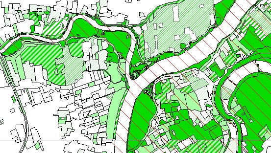
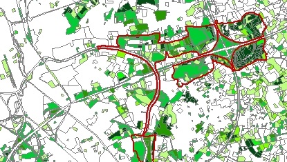
De Biologische Waarderingskaart (BWK) is een uniforme inventarisatie en evaluatie van het gehele Vlaamse grondgebied aan de hand van een set karteringseenheden die staan voor vegetaties, bodembedekking en kleine landschapselementen (lijn- en puntvormige elementen). Ook met de aanwezigheid van belangrijke fauna-elementen is er rekening gehouden. De vernieuwde BWK, versie 2, probeert, in vergelijking met de versie 1, aan meer vereisten en noden te voldoen, zowel inhoudelijk als op het gebied van nauwkeurigheid.
Simple
- Alternate title
-
BWK22
- Date (Publication date)
- 2010-09-16
- Date (Revision date)
- 2010-07-07
- Edition
-
BWK2 Versie 2.2 - Toestand 2010
- Citation identifier
- 58A28A84-61D4-11DC-8314-0800200C9A66
- Purpose
-
Aanmaken van een gebiedsdekkende biologische waarderingskaart teneinde een referentiekader te bieden voor biotoopinformatie en biologische waardering voor het Vlaamse gebiedsgerichte natuurbeleid.
- Status
- Historical archive
https://www.vlaanderen.be/inbo/home/
https://www.vlaanderen.be/inbo/home/
https://www.vlaanderen.be/inbo/home/
https://www.vlaanderen.be/digitaal-vlaanderen
- Keywords
-
-
NATUURBEHOUD
-
WAARDERINGSKAART
-
KWETSBAARHEID
-
DIVERSITEIT
-
WAARDERINGSZONE
-
WATERKWALITEIT
-
LANDSCHAPSELEMENTEN
-
BWK
-
BIOLOGISCHE WAARDERINGSKAART
-
ECOTOPEN
-
NATUURBELEID
-
BODEMBEDEKKING
-
BIOLOGISCHE WAARDERINGSKAART, VERSIE 2
-
BWK2
-
BIOTOOPINFORMATIE
-
BIOTOOPZELDZAAMHEID
-
VEGETATIETYPEN
-
ZELDZAME SOORTEN
-
FAUNISTISCH BELANGRIJKE GEBIEDEN
-
BIOLOGISCHE WAARDERING
-
BWK2.2
-
- Specific usage
-
Afleiden van cijfermateriaal over het areaal en de zeldzaamheid van de Vlaamse biotopen voor de natuurrapportage. Afleiden van andere digitale bestanden ten behoeve van de implementatie van de regionale en internationale regelgevingen en het Vlaamse gebiedsgerichte beleid.
https://www.vlaanderen.be/inbo/home/
- Use limitation
-
Beperking(en) op de publieke toegang
- Access constraints
- Other restrictions
- Other constraints
- Geen beperkingen op de publieke toegang.
- Use limitation
-
Toegangs- en (her)gebruiksvoorwaarden
- Use constraints
- Other restrictions
- Other constraints
-
De gegevens zijn beschermd door het auteursrecht. Indien u een ander type van gebruik wil maken van de gegevens, dan de hier vermelde, dient u zich te wenden tot de eigenaar van de gegevens.
- Other constraints
- Modellicentie voor gratis hergebruik
- Other constraints
- Gebruik voor taken van algemeen belang, van geografische gegevensbronnen toegevoegd aan de GDI, door deelnemers aan GDI-Vlaanderen
- Other constraints
- Gebruik voor taken van algemeen belang, van geografische gegevensbronnen toegevoegd aan de GDI, door instanties die geen deelnemer zijn aan GDI-Vlaanderen
- Other constraints
-
Bronvermeldingsvoorschrift: "Bron: INBO"
- Title
-
Biologische waarderingskaart, versie 1
- Alternate title
-
BWK
- Alternate title
-
BWK1
- Date (Revision date)
- 2006-05-16
- Date (Publication date)
- 1998-11-18
- Edition
-
1
- Citation identifier
- 6C12098F-785B-4662-8C2F-8DDC4E04DDF7
- Aggregate Datasetindentifier
- DA9C6CFF-6DF3-412A-B4C1-247C188BC638
- Association Type
- Cross reference
- Title
-
Bodembedekkingsbestand, opname 2001
- Date (Publication date)
- 2002-09-06
- Edition
-
Opname 2001
- Citation identifier
- 7E4A5C70-6F76-4C98-93F6-5FBEFA784939
- Aggregate Datasetindentifier
- F14B3B46-5728-4E65-8DFA-0D45D3A7A233
- Association Type
- Cross reference
- Title
-
Habitatrichtlijngebieden
- Alternate title
-
Speciale Beschermingszones in Vlaanderen in uitvoering van 92/43/EEG (Habitatrichtlijn)
- Date (Revision date)
- 2008-02-15
- Date (Publication date)
- 2008-02-15
- Edition
-
Toestand 15/02/2008
- Citation identifier
- 8ECA9691-37F1-40BE-9917-57C3639D3CE6
- Aggregate Datasetindentifier
- A84A87F5-5607-4019-A8DB-9D52A827786B
- Association Type
- Cross reference
- Spatial representation type
- Vector
- Denominator
- 3000
- Language
- Nederlands; Vlaams
- Character set
- 8859 Part 1
- Topic category
-
- Biota
- Environment
- Description
-
Vlaams Gewest
))
- Geographic identifier
- Vlaams Gewest
- Begin date
- 1997-01-01
- End date
- 2010-09-02
- Supplemental Information
-
Gespecifieerd in het afzonderlijk document per kaartblad "toelichtingXX", met XX het kaartbladnummer.
- Unique resource identifier
- Belge 1972 / Belgian Lambert 72
- Hierarchy level
- Dataset
- Statement
-
Aanmaak biologische waarderingskaart
- Description
-
Schermdigitalisatie van de op terrein afgebakende percelen en gebieden (inclusief inhoudelijke controle en aanpassingen) met de op dat ogenblik beschikbare digitale orthofoto's van het NGI als achtergrond (Ondersteunend Centrum GIS-Vlaanderen). Gemiddeld wordt ingezoomd tot 1/3000. Aanvullingen, bvb. grenzen die niet uit de digitale orthofoto’s kunnen afgeleid worden, gebeuren aan de hand interpretatie van de analoge Topografische kaarten van het NGI.
http://www.inbo.be
- Description
-
Controle van de schermdigitalisatie met de meest recente digitale orhofoto's van het NGI als achtergrond (Ondersteunend Centrum GIS-Vlaanderen). Elke nieuwe reeks ortho’s laat een betere interpretatie toe, zowel op inhoudelijk als geografisch vlak. Hoe recenter de digitalisatie, hoe beter de kwaliteit van de orthofoto’s en bijgevolg hoe beter de digitalisatie. Aanvullingen, bvb. grenzen die niet uit de digitale orthofoto's kunnen afgeleid worden, gebeuren aan de hand van de digitale topografische kaarten. Gemiddeld wordt ingezoomd tot 1/3000.
http://www.inbo.be
- Description
-
Topologie opbouwen van de individuele bestanden in een geodatabase (clustertolerance 0,1 m). Onderwerpen aan controleprogramma om uniforme, foutloze bestanden te bekomen.
http://www.inbo.be
- Description
-
Schermdigitalisatie van de faunistische belangrijke gebieden met de BWK en de digitale orthofoto's van het NGI als achtergrond (Ondersteunend Centrum GIS-Vlaanderen). Basisinformatie hiertoe zijn diverse databestanden.
http://www.inbo.be
- Description
-
Dissolve per kaartblok om kaartbladgrenzen te verwijderen
- Date / Time
- 2010-06-01T12:00:00
- Included with dataset
- Yes
- Feature catalogue citation
Meta-metadata
- File identifier
- 5D89DD1E-5C44-11DC-8314-0800200C9A66 XML
- Metadata language
- Nederlands; Vlaams
- Character set
- UTF8
- Hierarchy level
- Dataset
- Hierarchy level name
-
Dataset
- Date stamp
- 2025-11-18
- Metadata standard name
-
ISO 19115/2003/Cor.1:2006/INSPIRE-TG2.0
- Metadata standard version
-
GDI-Vlaanderen Best Practices - versie 2.0
https://www.vlaanderen.be/inbo/home/
)))