 Metadata Vlaanderen
3D-model 1:10.000
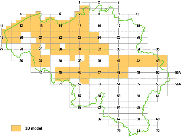
3D-model (in ontwikkeling) van gebouwen en wegen. Dit model is afgeleid van de 3D line map en van de DTM 1:10.000 of van de DTM 1:50.000 (DTED). De geometrie is fotogrammetrisch opgemeten vanaf luchtfoto’s op schaal 1:21.000. Voor een overzicht van de beschikbaarheid van deze dataset : zie afbeelding 1.
Simple
- Date (Revision date)
- 1999-05-27
- Citation identifier
- 223414C1-AAAC-44C0-B9D2-FDA86BA8E2E2
- Purpose
-
Wettelijke opdracht NGI.
- Status
- Completed
+32 2 629 82 12
https://www.ngi.be
+32 2 629 82 12
https://www.ngi.be
+32 2 629 82 12
https://www.ngi.be
- Keywords
-
-
LINE
-
NGI
-
WEGEN
-
GEBOUWEN
-
MODEL
-
DTM
-
DTED
-
3D-MODEL 1:10.000
-
- Specific usage
-
o.a. commercialisatie van het bestand.
+32 2 629 82 12
https://www.ngi.be
- Use limitation
-
Contact opnemen met NGI Eigendom en auteursrechten berusten bij het Nationaal Geografisch Instituut (NGI)
- Access constraints
- Copyright
- Use constraints
- License
- Title
-
3D Line map 1:10000
- Alternate title
-
3D LINE MAP
- Date (Revision date)
- 1999-05-21
- Citation identifier
- AA7C71B4-35DD-4234-8A16-538BC374F3AC
- Aggregate Datasetindentifier
- 65A235A5-9F68-4CE6-8A33-268E9C64E2EB
- Association Type
- Cross reference
- Title
-
Digitaal terreinmodel 1:10.000
- Alternate title
-
DTM 1:10.000
- Date (Revision date)
- 1999-05-27
- Citation identifier
- 782E5362-E941-4346-B891-3E7B7CB0C958
- Aggregate Datasetindentifier
- 80F35C5D-1A73-4891-A02E-DE0302CA7F3E
- Association Type
- Cross reference
- Spatial representation type
- Vector
- Denominator
- 10000
- Language
- Nederlands; Vlaams
- Character set
- 8859 Part 1
- Topic category
-
- Elevation
- Description
-
Huidige begrenzing
))
- Geographic identifier
- België
- Begin date
- 1900-01-01
- End date
- 1900-01-01
- Unique resource identifier
- Belge 1972 / Belgian Lambert 72
- Unique resource identifier
- Ostend height
Distributor
+32 2 629 82 12
https://www.ngi.be
- Fees
-
Zie eigenaar/verdeler
- Ordering instructions
-
Zie eigenaar/verdeler
- Units of distribution
-
Aanvragen bij het NGI
- Hierarchy level
- Dataset
- Statement
-
Aanmaak 3D Line map 1:10000
- Description
-
Opbouw 3D model.
+32 2 629 82 12
http://www.ngi.be
- Included with dataset
- Yes
- Feature catalogue citation
Meta-metadata
- File identifier
- FECDFE53-5F30-4B71-B68A-9B0B444B7A2E XML
- Metadata language
- Nederlands; Vlaams
- Character set
- UTF8
- Hierarchy level
- Dataset
- Hierarchy level name
-
Dataset
- Date stamp
- 2024-02-23
- Metadata standard name
-
ISO 19115/2003/Cor.1:2006
- Metadata standard version
-
GDI-Vlaanderen Best Practices - versie 1.0
)))