 Metadata Vlaanderen
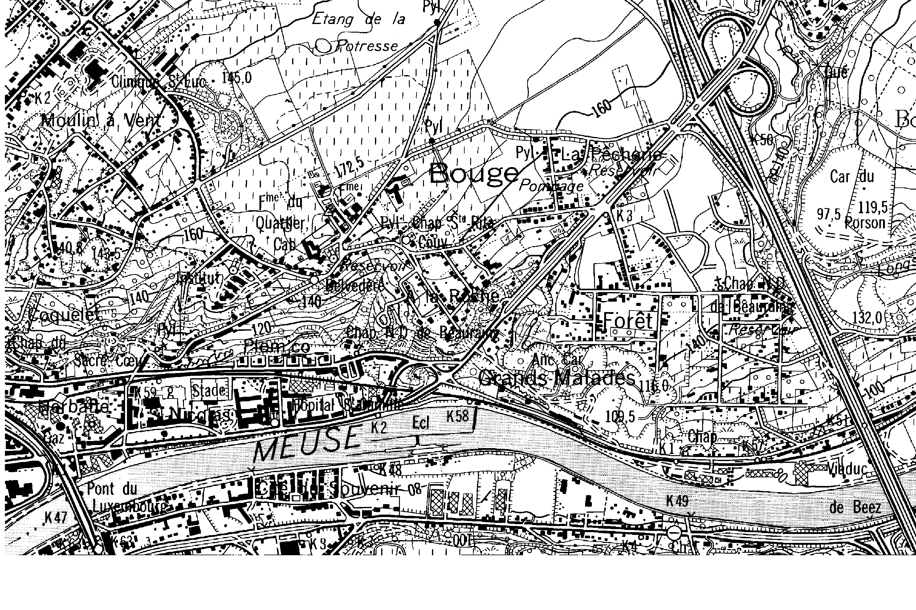
Topografische kaart 1 : 10 000 (1996) gescand
Deze rasterproducten geven ons de cartografische gegevens als een geheel van pixels (elementaire beelden). Ze worden bekomen door het scannen van de oorspronkelijke film (scannen analoge gegevens). De kaartserie 1:10.000 in “analoge stijl” (1972-1992) werd in zwart/wit gescand, en dit voor gans België. De resolutie van dit rasterbestand bedraagt 400 dpi voor Vlaanderen en Brussel, 300 dpi voor Wallonië.
Simple
- Alternate title
-
top10-s
- Date (Revision date)
- 1996-01-01
- Date (Publication date)
- 1999-05-27
- Citation identifier
- 08FE6EAF-3B41-4F26-B968-7B81C29534CE
- Purpose
-
Wettelijke opdracht NGI.
- Status
- Historical archive
+32 2 629 82 12
https://www.ngi.be
+32 2 629 82 12
https://www.ngi.be
+32 2 629 82 12
https://www.ngi.be
- Keywords
-
-
NGI
-
BEELDEN
-
RASTERBESTAND
-
BRUSSEL
-
RASTERPRODUCTEN
-
CARTOGRAFISCHE
-
KAARTSERIE
-
WALLONIë
-
NATIONAAL GEOGRAFISCH INSTITUUT
-
TOPOGRAFISCHE KAART 1/10.000 (1996) GESCAND
-
TOP-S
-
TOP10-S
-
GESCAND
-
TOP10S
-
TOP10RZW
-
TOPOGRAFIE
-
- Specific usage
-
o.a. het commercialiseren van het bestand.
+32 2 629 82 12
https://www.ngi.be
- Use limitation
-
Contact opnemen met NGI Eigendom en auteursrechten berusten bij het Nationaal Geografisch Instituut (NGI)
- Access constraints
- Copyright
- Use constraints
- License
- Spatial representation type
- Grid
- Denominator
- 5000
- Language
- Nederlands; Vlaams
- Language
- Français
- Language
- Deutsch
- Character set
- 8859 Part 1
- Topic category
-
- Imagery base maps earth cover
- Description
-
Huidige begrenzing
))
- Geographic identifier
- België
- Begin date
- 1972-01-01
- End date
- 1992-01-01
- Distribution format
-
Name Version TIFF Niet gekend
Distributor
+32 2 629 82 12
https://www.ngi.be
- Fees
-
139,07 euro per kaartblad van 80 km2.
- Ordering instructions
-
Zie eigenaar/verdeler
Digital transfer options
- Units of distribution
-
Kaartblad
- Hierarchy level
- Dataset
- Statement
-
Aanmaak topografische kaart, gescand
- Description
-
Scannen in zwart-wit van de analoge kaartreeks op schaal 1:10.000 (1972-1992), met een resolutie van 400 dpi voor Vlaanderen en Brussel, en 300 dpi voor Wallonië.
+32 2 629 82 12
http://www.ngi.be
- Included with dataset
- Yes
- Feature catalogue citation
Meta-metadata
- File identifier
- 7545ABE2-0E77-4E43-AA76-674EE59B24A9 XML
- Metadata language
- Nederlands; Vlaams
- Character set
- UTF8
- Hierarchy level
- Dataset
- Hierarchy level name
-
Dataset
- Date stamp
- 2025-11-18
- Metadata standard name
-
ISO 19115/2003/Cor.1:2006/INSPIRE-TG2.0
- Metadata standard version
-
GDI-Vlaanderen Best Practices - versie 2.0
https://www.vlaanderen.be/digitaal-vlaanderen
)))